The map and its basemap
The map is a MapLibre map in Web Mercator. Every layer you add is drawn on it from its own coordinate system, transformed as it goes, and the file on disk is left exactly as it was. Underneath everything sits the basemap: an online tile service, OpenStreetMap unless you pick another.
Moving around
Drag to pan, scroll or pinch to zoom, or click + and − at the top right. The zoom level reads at the right end of the status bar. Every row in the Layers tree has a crosshair, Zoom to layer, which fits the map to that layer, and a survey has Fit survey. With no survey open the map starts over the country and zoom set in Settings › Map · default area. A survey you open always fits its own extent instead.
The coordinates under the cursor
While the cursor is over the map, its longitude and latitude read at the bottom left above the scale bar, in WGS 84 to five decimals, in the order longitude, latitude. Objects show their own position in the object panel and the identify popover, with a second line in the layer's coordinate system when that is not WGS 84.
The basemap
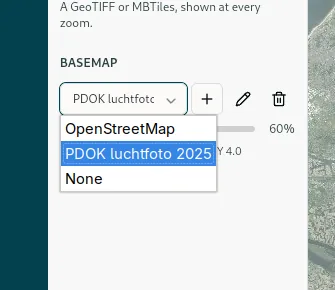
The last section of the Layers panel. OpenStreetMap is built in and chosen at every start, and None leaves you a blank canvas for the session. An Opacity slider dims the basemap under your own data, with the provider's attribution underneath. Tiles come live from the provider, so the basemap needs a connection. Without one, every layer you added still draws over a blank canvas, and a hint tells you why.
Your own tile service
The + beside the chooser adds a service of your own: an orthophoto server, a national map service, a company WMTS written out as tiles. Give it a Name and a Tile URL template, which has to start with https:// and contain {z}, {x} and {y} in any order. ArcGIS REST services put the path in the order …/tile/{z}/{y}/{x}, and {s} works through the Subdomains you list. Set Min zoom and Max zoom to the levels the service actually has tiles for; the map will still zoom past them and scale the last ones up. Tick TMS tile scheme if the map comes out upside down. Test fetches one sample tile and tells you what came back, and Save keeps the service on this computer. Once saved, it can be edited or removed with the buttons beside the chooser.
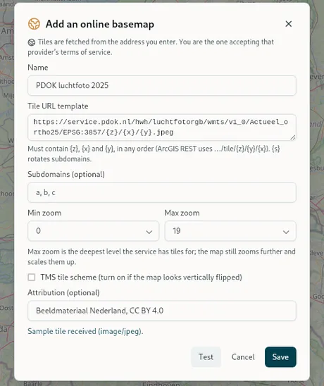
The notice in the dialog means what it says. Tiles are fetched from the address you type in, and you are the one agreeing to that provider's terms of service. A key or a token goes into the URL itself, as there is no separate field for it.