Opening a survey
Export a Tavak survey from the phone and you get one ZIP: the survey's GeoPackage with every layer, the GPS track, the photos and videos, the forms, whatever basemaps and reference datasets the survey used, and a metadata.json describing the lot. Homestead opens that ZIP as it stands, and never changes anything inside it.
Adding a survey
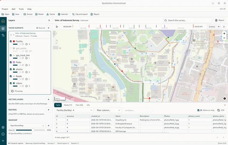
Add › Survey…, or Survey on the toolbar, or the + on the tree's Tavak surveys heading, then pick the ZIP. A bare survey GeoPackage works too, just without the media. The map fits the survey, its layers are drawn in the coordinate system the export was made in, with a badge on a layer's row naming the CRS when it differs, and the window grows the survey's top bar, the replay ribbon and the dock (see The window). You can have several surveys open at once, and picking one that is already open simply brings it to the front.
The survey in the tree
A survey row shows its title, then the surveyor, the layer count and the media count. The ZIP's path is in the tooltip, and the X closes it. With several open, click a collapsed survey to make it the active one. It expands to show its layers, each with the same visibility, opacity, hover-tip and zoom-to controls as any other layer, plus a Reference datasets group for the vector datasets and tilesets the survey carried, a Rasters in this backup group for its basemaps, and a Fit survey button. The top bar, the ribbon, the dock and the search all follow whichever survey is active.
The Info tab
Three cards. The first is the session: the surveyor, the device, when it started and ended, when it was exported, the Tavak version and export format, the size of the archive, the coordinate system, and the description. A verified badge means the GeoPackage's checksum matches what metadata.json recorded at export. Contents counts the GPS points, the feature points, lines and polygons, the photos and videos, including the ones held in an object's field, and the reference layers and tilesets. GeoPackage tables lists every table with its layer name, geometry, row count, spatial index and coordinate system.
The Files tab
Every file in the ZIP with its path, type and size: the GeoPackage, the media, the layers and basemaps folders, and the metadata. Think of it as the map of the archive, for when you want to take a piece of it somewhere else, the GeoPackage into QGIS for instance.
Where the rest is
- Replay: the ribbon plays the day back.
- Photos and videos: the Media tab and the lightbox.
- Looking things up: the identify popover, the Table tab and the search box.
- The PDF report: the survey as a document.