Rasters
A GeoTIFF from a drone flight, a scanned map with a world file, a JPEG 2000, a DEM, an MBTiles basemap: Add › Raster… puts any of them on the map, at every zoom. The formats page lists thirty-odd of them. Every raster needs two things. It has to be georeferenced, and it has to carry a coordinate system, either in the file or in a world file with a .prj or .aux.xml beside it. Without one, the open fails with GDAL could not place this raster on the globe.
The pyramid
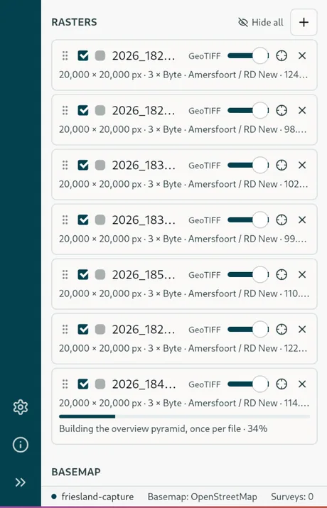
A raster is drawn through a pyramid of overviews. A Cloud Optimized GeoTIFF or an MBTiles brings its own and appears at once. Anything else has one built for it in Homestead's cache the first time it is opened, in the background, with the progress in the raster's row (Building the overview pyramid, once per file). Until it finishes, only the finest zooms draw, and the row reads Only zoom N+ draws until the pyramid is built. If the build fails there is a Retry on the row. Pyramids build one at a time, so several rasters added together finish one after another, each one usable as soon as its own is done. The source file is never written to.
The pyramid is in Web Mercator, so the raster is warped once into the map's projection. The export in Clip and export works from the original instead, and keeps its coordinate system.
The rows in the tree
A raster row holds the grip you drag it by, since the order is the drawing order; the visibility tick; its name, with the path in the tooltip; a GeoTIFF or MBTiles tag; the opacity slider; the crosshair that zooms to it; and Remove. The detail line underneath gives the size in pixels, the bands and their type, the coordinate system and the file size. For an MBTiles it gives the tile count, the format and the zoom range instead.
Three bands draw as RGB, one band as grey, a Float32 DEM among them, scaled to its own range, and a colour table is expanded. Rasters draw under the vector layers and over the basemap, and the Rasters heading has its own Show all and Hide all.
Rasters in a backup
A Tavak backup may bring the basemaps the phone was using, an MBTiles orthophoto for instance. Those are listed under the survey in the tree as Rasters in this backup, and any vector tilesets as Reference datasets, each with a tick, an opacity slider and a zoom-to. See Opening a survey.